Visiting
The Reserve is free to visit, 365 days of the year and everyone is welcome. To help us (the Conservation Group) and the those who will follow you to enjoy and maintain this resource, please consider the birds, flora and fauna here as residents; we are merely visiting observers. The less environmental impact that we make, the better it is for all. The Conservation Group respectfully asks you to:
- Keep your dog on a lead and clean up any mess (there is a recreation ground with dog bin adjacent to the Reserve)
- Save games for the recreation ground nearby
- Bring your camera, binoculars, sketchbook
- Don’t just walk through, stop, look, listen
- Keep to the paths, especially in the summer nesting season
- Absolutely NO fires – this was a coal mine!
- Leave no trace
Access
The Reserve has a two swing stiles; one at the eastern (Village) side and the other at the western side along the recreation ground access track. There is a solid (not tarmaced) circuit path through the Reserve and smaller, less well defined paths through the wooded areas. Stout shoes are recommended. The two bridges over ponds have been refurbished in 2017 and are now wide enough for wheelchairs and buggies.
How to get here
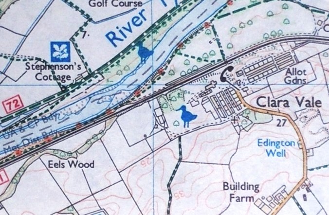
The Reserve is located at Clara Vale (Ordnance Survey Grid Reference NZ 131648), on the southern (Gateshead) side of the river Tyne.
By Bicycle: There are many possibilities for including a visit to the Reserve on a cycle ride. One of the most popular is to use the Keelmans Way (River Tyne south bank) path, national cycle network route 141, from the east or west. There is a hard surfaced shared path across the Ryton golf course from the river at grid reference NZ 132652. Proceed over the level crossing, up the slope and turn right. Head between the houses where the road becomes a track to enter the Reserve from the eastern side.
On Foot: Again, there are numerous possibilities, OS maps will show footpaths from Wylam, Ryton and Crawcrook.
By Bus: There is a regular bus service from Crawcrook with stops as far away as Rowlands Gill on the Travel North East R3 service and interconnecting services from a wide area.
By Car: Turn left at the War Memorial as you enter the village from Stannerford Road and follow the track. There is limited parking to the left, just before the entrance to the recreation ground. Opposite the parking area is a stile giving access to the Reserve.
Leaflet: You can download your own copy here